

Truck driving is not just a job. It’s a lifestyle! Likewise if you’ve decided to drive your RV across country or your motor home to the Grand Canyon or Niagara Falls, it essentially means putting aside your day-to-day style of life and embarking on another; another more liberating, exciting and adventurous lifestyle for awhile!

This sort of lifestyle change takes courage, commitment, and above all, education because anyone driving a very large or heavy vehicle on public roads needs this vital information to travel on mountain passes, steep grades or just the wide and wild open expanses of our wondrous land.
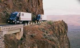
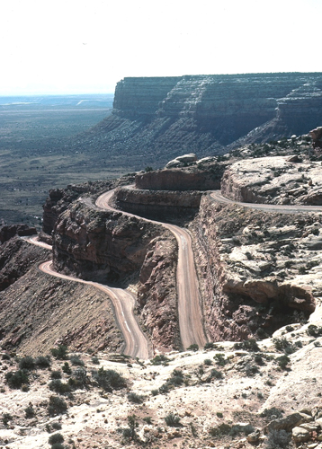
There is an old saying among over-the-road truckers. “There are two kinds of drivers — those who’ve been in trouble on a mountain grade, and those who will be.” Unfortunately, this also applies to many RVers. Trucks, RVs and motor homes have similar problems regarding weight, engine power, and braking in mountainous terrain.

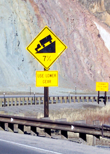
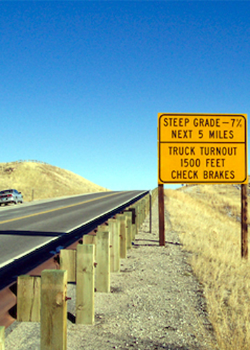
In an attempt to make mountain driving a little safer for truckers and RVs and motor homes, R&R Publishing Inc. has been collecting and 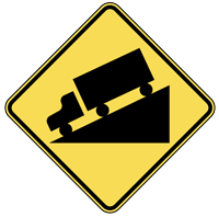 publishing information about mountain passes and steep grades since 1993. The Mountain Directory Ebooks give the locations and descriptions of over 700 mountain passes and steep grades in 22 states. The Mountain Directory ebooks tell you where the steep grades are, how long they are, how steep (%) they are, whether the road is two lane, three lane, or four lane, if there are escape ramps, switchbacks, sharp curves, speed limits, etc. With this information, one can know ahead of time what a pass is like and make an informed decision about whether to go over or around. If you decide to go over, perhaps the cool morning hours would ease the strain on the engine and transmission during the climb. Unhooking the towed vehicle would make the climb and the descent easier. Knowing what lies ahead is half the battle.
The printed versions of the Mountain Directory books had almost 240 pages of text and color relief maps. All 240 pages are in the downloadable versions of the Mountain Directory ebooks. Nothing is missing. In the printed versions, mountain pass locations were marked with a yellow triangle on the color relief maps. In the ebook versions, you can click on the yellow triangles and the text appears that describes that location.
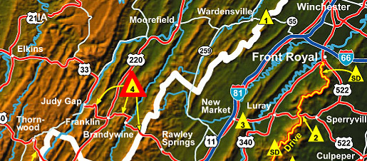
4. US 33 (between Harrisonburg, VA and Judy Gap, WV.)
There are three summits along this stretch of US 33. The eastern summit is between Rawley Springs, VA and Brandywine, WV. The east side is 4 miles of 8 to 9% grade. The west side is 4½ miles of 9% grade and both sides have continuous sharp curves and hairpin turns. The highway is two lane on both sides.
The middle summit is between Oak Flat and Franklin, WV. The east side of this hill is 2½ miles of 8% with 25 mph curves. The west side is about 3½ miles of much milder grade. It is 4 to 5% over most of its length. There are some sharp curves near the bottom. The road is two lane on both sides of the hill.
The western summit is between Franklin and Judy Gap, WV. It is 5 miles of steady 9% grade on both sides. Both sides are two lane with sharp curves and hairpin turns. Use caution on this road.
Imagine yourself descending a mountain grade in your RV. You didn’t know there was such a long, steep grade on this highway. What a surprise! And things are not going well. You have a white-knuckle grip on the steering wheel. The engine is not holding back all of this weight, the brakes are smelling hot or even smoking, you’re pushing harder on the brake pedal but your speed keeps increasing. All you can see ahead is more mountain. Your mind is racing through all of the available options and none of them are good. “I’ve got to do something,” you say “or I’m not going to make it.” The options include: run into the rock wall, go over the side, hit those trees, or see if you can make the next curve and ride it out. You choose the last option and, if you are lucky, you make it to the bottom in one piece. You pull over and while you are waiting for your heart to stop pounding, you wipe the sweat from your face and you notice your shirt is soaked, your mouth is dry, and your hands are shaking. You are thinking, “If I had known it was going to be like that….!”
Perhaps your rig has difficulty during the steep climbs. The temperature is in the 90’s and the grade is so steep that you can barely climb it in first gear. The engine and transmission temperatures are rising. How far to the top of this hill? You don’t know if it’s one mile or ten. Something smells hot. What to do? Pull over and cool off? But then all momentum is lost. Can you even get started again? You wish you had unhooked the car you’re dragging up this hill behind the motorhome. If you are lucky, you can do that next time. You are wondering how many thousand dollars a new engine and transmission will be.
 During the last few years we have heard many stories about very expensive repairs to drive train components. Sometimes rigs are lost entirely. A highway patrol officer in Oregon told us that in the summer an average of one motor home per week burns to the ground while trying to climb Cabbage Hill on I-84 east of Pendleton. If a fire starts, the nearest fire department is likely to be many miles away. By the time they arrive, there is nothing left to do but hose down the ashes.
Many people are under the impression that the grades in the eastern mountains are not as serious as the grades in the western mountains. Apparently this is because the elevations are not as high in the eastern states. But elevation alone is not the problem–it is the change in elevation that makes a grade potentially hazardous. If all other factors are equal, a grade that descends from 4000′ to 1000′ over 10 miles is no different than a grade that descends from 10000′ to 7000′ over 10 miles. Either way you have a 3000′ change in elevation spread over 10 miles. (This example would result in an average grade of almost 6% for 10 miles.)
 A large percentage of the grades in the western states are in the 6% range. A large percentage of the grades in the eastern states are 8, 9, or 10% and sometimes even more. The eastern grades are often shorter but this is not always so. A quick glance through the eastern book will reveal over 50 grades that are between 7 and 10% and from 4 to 7 miles long. There are others that are even more challenging. The road to the top of Whiteface Mountain in New York is 8 to 10% for 8 miles. There would be no need for truckers to use this road but RVs are allowed. Near Cumberland, Maryland there is a hill on I-68 that is posted as 6% for 13 miles. In North Carolina highway 181 crosses the Blue Ridge Parkway and the southbound descent is 11 miles of grade that varies from 6 to 10%. Much of it is 8 to 9%. These grades are just as hazardous as the grades in the western states.
While every effort has been made to ensure the accuracy of the maps included in this book, it is nearly impossible to include all necessary detail on such small maps. We recommend that these maps be used in conjunction with larger, more detailed road maps.
 In most cases the passes and hills are described as descents. In other words, a pass will be described from the summit down in one direction and then from the summit down in the other direction. This directory does not claim to include every steep grade. In fact, because of the enormous area we have tried to cover, we can guarantee that we have probably missed some. Sometimes the percentages quoted are estimates and many times they are based on road signs or information provided by highway departments. This book does not attempt to rate passes or grades according to difficulty. There is an enormous variety in vehicles and equipment. A hill that is very difficult for one vehicle may be no problem at all for a similar vehicle that is equipped differently. Driver judgment is critical in deciding which hills should be avoided.
 The purpose of this book is not to discourage drivers from going where they please. It is only to inform them of the conditions they may encounter and to encourage them to make sure their equipment is in good repair. Brakes must be in good working order and properly adjusted and the engine and transmission should be used to slow the vehicle whenever possible, thus saving the brakes and keeping them cool enough to retain their stopping power. The engine’s cooling system should be in good repair to prevent overheating during the climbs. Turning off the air conditioner during climbs may help, and if necessary, turning on the heater will help dissipate heat from the engine.
Remember the old phrase, “You can go down a mountain a thousand times too slowly, but only once too fast.”
TRY BEFORE YOU BUY! CHECK OUT THE FREE DEMO AND SEE HOW IT WORKS!
CLICK HERE FOR FULL DETAILS & GET STARTED NOW